Picking Will up with his bike at the McDonalds near the Salt Lake City Airport was a smooth operation. We arrived in Moab with time for a shake down cruise which Will had carefully planned, but big floods in the town in 2023 and 2024 had pretty much ruined the trails planned for our shake down cruise.
Day 0 - Thur 15 May 25
Field Station Motel to Pipe Dream Trail & Colorado Bicycle Bridge
7.9 miles, 1:07 riding time, 472 ft elevation gain
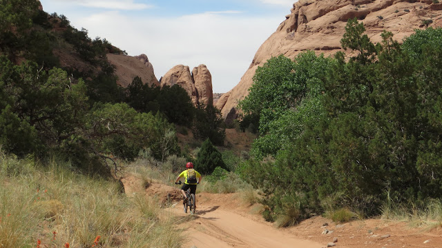
Will's planning was likely good, but when we got to the Pipe Dream Trail and started climbing straight up the hill, we found a washed out gully with large river rocks filling parts of it. Will could ride much of it; I couldn't. When we got high enough that the trail started across the hill instead of up it, I found it ride-able but not very enjoyable, so we headed off to the Colorado Bicycle Bridge for a few photos. A couple days later our shuttle driver would tell us the trails become ride-able about the time it gets to the water tank which we were nearing.
 |
Will and Steve on the Pipe Dream Tail- photo by Will
|
 |
Will on the Pipe Dream Trail nearing the Watertower where the trail may have smoothed out a bit
|
 |
Will on a smoother section of the Pipe Dream Trail overlooking Moab
|
 |
Bikes ready to be ridden at the Colorado River bicycle bridge
|
We rode back to the Proper Brewing & Burger for dinner and then back to the motel.
Day 1- Fri 16 May 25
Flat Pass and Steel Bender Jeep Trail
30.8 miles, 5:48 riding time, 2,972 ft elevation gain
We climbed a few miles out of town on pavement and then gravel before turning onto Flat Pass Rd, passing by a popular campground at a small lake, and starting up the steep grade that is Flat Pass.
 |
Will on the way out of town
|
 |
Will stops to contemplate the rocks nearing the top of Flat Pass
|
Soon after crossing the pass, the route transitioned to the Steel Bender Jeep Trail- beautiful but rugged which required much pushing.
 |
Will where Flat Pass become the Jeep trail Steel Bender
|
 |
Will starting up Steel Bender- it still looks like a road here
|
Steel Bender Jeep Trail with the La Sal Mountains in the backgroundWe soon had our first creek crossing, and the smooth jeep trail was no longer smooth:
 |
Steve on the first creek crossing- the drop into the stream was a bit too much to ride. - photo from Will's video
|
 |
Will as the smooth trail turns rougher
|
 |
Will smoothy rides these drops
|
 |
We were passed by a couple or three friendly "jeep" caravans
|
 |
Getting the "jeeps" to the top was sometimes a challenge for the "jeeps" as well as us, and here the passengers waited safely outside the "jeeps" - photo by Will
|
 |
Steve beginning the climb up thru a canyon- photo by Will
|
 |
Steve pushing- photo by Will
|
 |
Will on Mills Creek
|
Will had psyched me up for 4 creek crossing, but the last 3 on Mill Creek were easily ridden. Our plan would have brought us into Moab on Mill Creek, but floods had closed that trail, so we were diverted over a significant ridge on another jeep road and back down into Moab- missing Mill Creek Waterfall. Still the riding time was 5:48 with lots of pushing, so we were ready for our drive-in dinner at Mill's Stop and Eats and an early return to the motel.
Day 2- Sat 17 May 25
Sand Flats Road, Eagle Eye, Hawks Glide, and Falcon Flow Trails
33.8 miles, 6:28 riding time, 4,275 ft elevation gain
We've ridden Sand Flats Road several time. It's long with some steep sections, but it requires no pushing.
 |
Steve on a large rock- note Sand Flats Rd on the left of the photo
|
 |
Will on a short paved section of Sand Flats Rd- nearing the top
|
 |
But it's a false top. Steep climbing remains
|
By the time we'd climbed all of Sand Flats Rd, we were ready for lunch which we enjoyed on the edge of Porcupine Ridge as one bicycle after another buzzed by us. I wouldn't recommend riding Porcupine Ridge or "The Whole Enchilada" on a Saturday or Sunday, but our route wasn't down that crowded trail. It was down Eagle Eye, for me a somewhat challenging but fun trail where I only occasionally pushed. Will rides it faster and then patiently waits for me.
 |
Will and Steve at the Porcupine Rim overlook lunch spot- photo by Will
|
 |
Steve on Eagle Eye- photo by Will
|
 |
Eagle Eye ends and Hawks Glide begins- photo by Will
|
Hawks Glide begins much like Eagle Eye, but toward its end it has a seriously technical section thru which I pushed!
 |
Will at the sign that reads, "CAUTION, ADVANCED TRAIL AHEAD, Expect cliff exposure and technical riding".
|
 |
Steve pushing down part of Hawks Glide- photo by Will
|
 |
This looks too technical for me, but here I am- photo by Will
|
We got back on Sands Flat road for 100 ft or maybe 100 yards and turned onto Falcon Flow which is fun and again at my technical max but it remained enjoyable with little pushing. Its elevation is low enough that it has a few sand traps and interesting short but steep climbs, but we took no photos the rest of the day. The day was tough, so we ate dinner at the "Moab Diner" without cleaning up and rode back to the motel where we showered and went to bed early.
Day 3- Sun 18 May 25
Rain alters our plans for the Mag 7 shuttle and we ride part of Bartlett Wash
10.8 miles, 2:05 riding time, 767 ft elevation gain
We awoke to light drizzle with the weather forecast predicting 0.08" of rain for the day which left Will determined to follow the plan. In our room he fixed oatmeal with lots of toppings which was quite tasty, and with some reluctance on my part we rode to Chile Pepper Bike shop where we were to catch a shuttle which was advertised as running "rain or shine". I think Will was disappointed that the shuttle was cancelled or postponed until the next day. I was quite happy to ride back to the motel in the continuing drizzle knowing that a shuttle wasn't going to drop me off in the rain hours from town.
 |
Light drizzle continued all morning. Here we are back at the motel.- photo by Will
|
 |
Steve riding away from the car - in the rain- photo by Will
|
I was lobbying for a drive to Canyonlands or one of the area parks, but Will was convinced the predicted 0.08" of rain was all the rain we'd get, so I reluctantly and he eagerly loaded the bikes up for the drive to Bartlett Wash, the ride we had planned for the next day. Rain fell on the drive out and continued as we unloaded the bikes, but within minutes of hopping on the bikes, the drizzle stopped. As sticky as slick rock is, it isn't at all sticky with wet sand stuck in the tread of the tires and shoes! With that sand stuck in our tread we had trouble climbing up the first rock face, but soon figured out the problem and fixed it by dipping our tires and shoes in some of the many puddles of water standing on the slick rock.
 |
Getting ourselves and the bikes up this slickrock was difficult when the tread of our shoes and tires was filled with wet sand, but we soon discovered the sand was easily washed out in the puddles.- photo by Will
|
The plan had called for riding the slick rock of Bartlett Wash and continuing on trails or jeep trails over to Monitor and Merrimack- a favorite of ours. We'd had well over the predicted 0.08" of rain, but "possible thunderstorms" remained in the prediction for the afternoon. However, it wasn't raining, and we were enjoying Bartlett Wash's slickrock.
 |
Me trying to decide which layer of slick rock to ride- photo by Will
|
We enjoyed the slick rock. Will rode the "toilet bowl", and we had lunch. Then Will looked at the clouds, and said, "that T storm will be here within 15 minutes, we need to get back to the car".
 |
Steve running from the storm that is about 5 minutes from striking. - photo by Will
|
Will climbed in the car a moment or two before the rain started. I was still latching my bike to the roof, but I was hit only by a few big drops, and hopped in the car as the deluge started. We'd managed to enjoy the day's only 2 hours of pleasant weather on Bartlett Wash. We drove back in the storm recorded below and were delighted we weren't a minute later.
Day 4- Mon 19 May 25
To Chili Pepper's shuttle and the Mag 4 switched to the Magnificent 7
31.7 miles, 7:57 riding time, 2,543 ft elevation gainThe fellows at the bike shop were delighted for our choice of the Mag 4 noting that the damp sand would be ideal riding as they tried to talk 4 other shuttle passengers into switching to this route from the Porcupine Rim route which they said would have a lot of muddy clay to ride thru. From our perspective, they were right. The wet sand wasn't sticky like Boise's, but it rode like dry dirt without the dust! We could lean into corners, never spun out, and never threw sand. Even in Moab our bikes stayed clean!
 |
Steve & Will being dropped off for the first 4 of the Magnificent 7- photo by Will
|
After riding up from town in 2021 we had done most of the first 4 trails of the Magnificent 7 and then turned onto Gemini Bridges Rd, but that left Will all the more eager to ride the Magnificent 7. In the years since we have talked to riders who had travelled over that route, but most were better riders than I and said they did a lot of pushing, so I resisted. Today's ride on Getaway, Little Canyon Goldbar Rim, and Golden Spike was pleasant.
 |
These trails were fun if a little rough
|
 |
Will on a sharp corner
|
 |
Will attempting his usual after lunch nap mostly under a rock as a T storm threatened but didn't find us today
|
Then we ran into the below sign. It wasn't hard for Will to convince me to ride the 1 mile of "fun single track to the Bridge Canyon Rim".
When we reached the end of the "fun single-track", I got the sales pitch that it would be quicker to continue on to Moab, and it might get dark if we rode back to Gemini Bridge. I knew that was baloney and that darkness was more apt to fall on us on the Portal Trail, but I also knew we each had the endurance to continue (though even Will isn't an "expert" and I'm far from it). People we had talked to advised this would be a lot of pushing, so I was prepared for that. I also knew this was a "bucket list" item for Will, so I agreed to continue despite my fear that darkness would catch us before we reached Moab.
Just after the fabulous views below, there was a lot of pushing.
 |
Looking down on Moab Canyon with the La Sals in the background
|
 |
Looking up Moab Canyon
|
 |
Will with the Colorado River and edge of Moab in the background. The photographer should have had him stand back another foot or two!
|
 |
Will with Moab and the La Sals in the background
|
 |
Steve standing above Moab Canyon- photo by Will
|
 |
Will and Steve starting down the Portal Trail- photo by Will
|
 |
The first warning sign CAUTION Narrow dangerous bike trail ahead Prepare to dismount- photo by WIll
|
 |
Steve pushing on the Portal Trail- photo by Will
|
 |
Warning sign: Warning Extreme Exposure Trail ahead runs along cliff edge. Please dismount. People have died here - photo by Will
|
 |
DISMOUNT NOW! DO NOT RIDE OVER THE NEXT ROCK 200 FT CLIFF Riders have died here- riders just like you! - photo by Will
|
 |
Steve descending a lower portion of Portal Trail - photo by Will
|
 |
Safely on the outskirts of Moab- photo by Will
|
The trip down was a bit harrowing, but the views were worth a lot! Dusk was falling fast.
 |
Flash photo taken as dusk is fading into night as we reach the motel with only Will's inadequate light.
|
Though we usually do our in town chores on the bicycles, our late arrival caused us to drive into town for super and a rather late "lights out" before tomorrow's 0530 wake up.
Day 5- Tue 20 May 25
Bar M Trails as we head home
6.1 miles, 1:15 riding time, 453 ft of elevation gain
To make the end of our vacations less abrupt, we try to get in an hour or more of riding- usually on the Bar M trails as we leave the Moab area. We arrived there as the sun was coming up over the ridge just to our east. That kept the sun in our eyes and shadows at our tires which is a poor combination for me to see though it didn't seem to bother Will. I was usually far behind him wondering how he rode the drops (or risers) so quickly. He got far enough ahead of me that we separated, but we both knew where the car was, and we ended up with about the same mileage though he had more elevation gain as he went down Moab Canyon as planned, and I headed back to the car the long way.
 |
Steve on a smooth section of the chosen route at Bar M- photo by Will
|
 |
Will on a section of Bar M Trails
|
 |
Steve on that same section of Bar M Trails
|
I dropped Will off at the SLC Airport and drove on home alone.
Food options in Moab like many tourist areas change constantly, but there's a definite overall improvement since the poor experience we had in 2021 in the wake of COVID.
Thanks, Will for another great vacation and adventure!
Happy bicycling for fun, fitness, and transportation!
Steve
Our preferred maps
2022 Moab Trip
2021 Moab Trip2019 Moab Trip
2018 Moab trip
2016 Moab trip
2010 Moab trip


.jpg)


