I'd picked Will up in Salt Lake for the roughly 5 more hours of driving to Moab. When we arrived, we headed for the bike shop to pick up Will's rented 27.5" Canondale Trigger which he'd researched, particularly wanted, and had pre-paid the rent. Well, with an explanation that they'd sold the bike that they had rented to him and without an apology they offered him a 29" Canondale Habit. A couple of years ago he'd rented a 29er in Spokane and was sure he didn't like them, and he particularly wanted the "Trigger" which lets him adjust his rear shock from the handlebars a feature the Habit doesn't have. He reluctantly accepted the substitution, and we took off for a short "shake down cruise" to make sure it fit and get a bit of exercise after a day of travel
Day 0 - Wed 2 Oct 2019
Virginia Motel to Sunset Grill & on to the Colorado River
Bridge
8.0 miles 1:00 riding time 432 elevation gain
I thought we were just headed down to the bicycle bridge over the Colorado River where we'd take a photo or two and test out Will's rental bike for fit and obvious mechanical issues, but when Will noticed the steep ascent to Sunset Grill, we had to climb that pavement which my GPS showed had a maximum grade of 19%. It had a good overlook of Moab.
 |
| Steve & Will on the bicycle bridge over the Colorado |
 |
| Steve with Moab in the background - taken from the Sunset Grill |
Day 1 - Thur 3 Oct 2019
7-Up Trail and Bull Run Trails
31.0 miles 6:03 riding time 432 elevation gain
We were unsure of the amount of time this ride would take, so we drove hwy 191, turned SW on hwy 313 , parked, and rode our bikes up the steep road to the unmarked trail head skipping the roughly 12 miles (each way) of mostly paved bike path from Moab. With no sign, Will's GPS was all that showed us where the trail head was.
 |
| Will at the first sign verifying we were on the 7-Up Trail more than a mile after leaving the road |
 |
| Will on the 7-Up Trail |
 |
| another scene on the 7-Up Trail |
 |
| Will on 7-Up Trail |
 |
| Steve on his hard tail coming down some light drops (I believe we're on Bull Run here) |
|
We had planned to go from "Bull Run" on to ride five of the "Magnificent Seven" On the hard tail I was finding "Bull Run" too technical to enjoy, and the last two of the Magnificent Seven are for "Experts", so we caught a Jeep Trail road back. The hard tail was good for the up hill on 7-Up.
 |
| Steve with the road below him |
One last climb awaited us.
 |
| Steve in the difficult lighting above Moab Canyon; we'll rapidly drop down to that highway |
Day 2 - Fri 4 Oct 2019
to Arches National Park via Sovereign, Hot Dog, Red Hot, Carousel, The Edge Boondock, and a few other trails
42.0 miles 5:43 riding time 1,988 elevation gain
The weather for this trip was nearly ideal letting us escape the early cold front that had settled over the Pacific Northwest and even down to Salt Lake, but today was forecast to be windy with gusts up to 45 MPH. We'd stick to the plan. We've seen the park (which is great) and enjoy the trails that run near Willow Creek Rd getting there, so we rode to the boundary and on to the park's main highway where we turned around.
 |
| Steve over the canyon alongside the Sovereign Trail |
 |
| Will - the trail descending is more challenging than it appears |
 |
| Steve may or may not have ridden all the way down this rocky hill that is the hill behind Will in the last photo |
 |
| Will on a more typical (and pleasant) trail for the day |
 |
| Steve & Will at the entrance to Arches NP |
 |
| Will on a sweet section of trail |
We stopped at the Chevron Station about 12 miles out of town for ice cream where the worst of the wind caught us with gusts that may have reached the predicted 45MPH as we were enjoying that ice cream. The severe wind didn't last long, but we still fought a significant headwind down the bike path to Moab, but it was paved and downhill.
Day 3 - Sat 5 Oct 2019
Monitor & Merrimack, Wipe Out Ridge, and Ramblin' Trails
48.7miles 6:43 riding time 3,347 elevation gain
We'd done Monitor & Merrimack in 2018, and we both wanted to do it again, but Will wanted to change the route, and I agreed as there isn't enough light in Oct to do the 2018 route which had taken us into Arches National Park after circling Monitor and Merrimack. The 2018 route had some sandy sections that were doable because it was downhill. This revised route required some pushing as there was a lot more sand and most of it was not down hill.
 |
| Will on some of the "slick rock" near Monitor and Merrimack |
 |
| Will in more slick rock |
 |
| Steve just before the slick rock turned to sand! |
 |
| It's now sandy and hard to navigate but mostly ridable. Monitor & Merrimack in the background |
 |
| We're through the sand and onto "Ramblin'" where Will is enjoying the slickrock |
Ramblin' Trail was a pleasant surprise coming out of all that sand. It had a little bit of everything: slick rock, sand, smooth trails, twists, and changing terrain, and may be one of my favorites.
Day 4 - Sun 6 Oct 2018
Most of the Whole Enchilada
33.8 miles 5:09 riding time 1,499 elevation gain
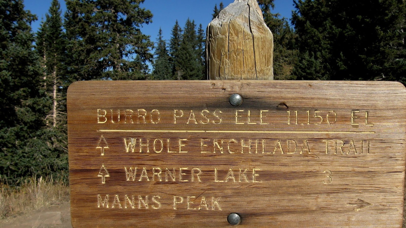
I knew the Whole Enchilada was the highlight of the trip for Will, but last year I hadn't enjoyed the portion above Porcupine Ridge as it was too rocky. Still, I was willing to go for it. Last year's snow made them drop us off at "Hazard County", but this year we'd go all the way to the official starting point on the far side of Burro Pass. Climbing from the drop off point to Burro Pass was challenging and fun though we both had to push for a short way, and at 11,150 ft we knew we were short of oxygen. When we reached the summit, we were ahead of most of the roughly 36 people who'd arrived with us on 3 shuttle vans.
 |
| Steve and Will at the top of Burro Pass |
 |
| Burro Pass elevation 11,150 ft |
 |
A small portion of the group at the top of Burro Pass - photo by Will
|
The initial descent was fun with some rock, but then we turned a corner, and the trails seemed to be mostly 5" rolling rocks buried to various depths in 6" of fine dust. I found myself going slow trying to control the bike. Will rode this section with Patrick, who had been crowded into our seat in the shuttle ride, and his girlfriend Stephanie fell back with me. Steph then announced that the trail was too technical for her. Right, it was also too technical for me, and as we went down this hill most of the 36 people who had been behind me were now passing me. I tried to speed up just a bit, but my desire for control was too strong, and I did an endo bruising my chest and thigh and scraping my leg just below my knee. My bike nearly fell on its derailer, but I saw that in mid-air and deflected it with my foot. I was glad the bike and knee escaped injury, but my confidence was gone as I kept hearing Steph say the route was too technical for her. My thigh didn't want to work the rest of the day, and my preference for uphill was strengthened. This combination of rocks buried in dust lasts quite a while longer, and as I was pushing through it nearly everyone passed me. I did notice that no one seemed in control of his bike. Back wheels were fish-tailing in one direction and front-ends doing the same in un-coordinated movements. However, other riders were speeding, hooping, and laughing all the way down with little or no use of the brakes. I also met a young man who had broken his derailer off, and whose attempts to shorten his chain had failed giving him no chain. He coasted down and pushed up the hills as he headed for Sand Road where he hoped to make a rapid descent to Moab.
 |
| Scenery near the site of my wreck |
I thought Will might be waiting for me at "Hazard County", but no one was there. Then it was back uphill for a short pleasant while.
 |
The climb up from Hazard County brings this kind of scenery - photo by Will
|
 |
Near the top after climbing out of Hazard County - Photo by Will
|
My chest hurt with each breath, my thigh hurt with each peddle stroke, and my confidence was gone, so I was pushing on most of the downhills until the trail meets the Kokopelli Trail where Will was waiting for me. It turns out he, Patrick, and Stephanie had all had endos, but with no broken body or bike parts and with their confidence still intact and!
 |
Steve back on his bike on the Kokopelli Trail - photo by Will
|
 |
| View of the valley |
 |
| Will resting after lunch |
 |
| Steve from their lunch spot |
Like the guy with the broken chain, Steph planned to abandon the ride at Sand Road taking it back to Moab, and from shortly after my wreck that was my desire though I wanted Will to enjoy this ride and I really like riding down Porcupine Rim although it tests my technical skills. Will gave up Porcupine Ridge and accompanied me back to Moab on Sand Road.
Day 5 - Mon 7 Oct 2019
Klondike Bluff Trails: Jurasic, Jasper West, Agate West, Chilkook Pass, Homer, Alaska, Old Salty, Baby Steps, UFO, Klondike Bluffs, and Jurasic Trails
22.6 miles 3:53 riding time 1,732 elevation gain
My thigh and chest hurt less than yesterday, but my attitude wasn't as positive as it should have been when we started out. However, today my leg was functioning properly, and soon my confidence and enjoyment of the ride increased, but I notice nearly all the photos were taken by Will.
 |
Klondike Bluffs Trailhead - photo by Will
|
 |
Steve on some of the slick rock - photo by Will
|
 |
Steve on these very enjoyable trails - photo by Will
|
 |
| Will on his 29er Habit |
 |
| Will |
 |
| Big rocks, but well designed trails! |
 |
Steve riding the ridge -photo by Will
|
It was another great trip although I'm unlikely to attempt The Whole Enchilada again. Thanks for the memories Will
Online maps seem better each year, here's the maps we relied on.
Happy bicycling for fun, fitness, and transportation
Steve
2018 Moab trip
2016 Moab trip
2010 Moab trip