I've wanted to bicycle the Selkirk Loop since I first saw it on Adventure Cycling routes maybe 15 years ago, so when Christy invited me to join a group of her friends, I was eager.
Day 0: Sun 8 Jul 2018
Post Falls, ID to Sandpoint, ID
63.3 miles, 5:53 riding time, 1972 elevation gain
Since my nephew, Troy, lives about a day's ride from the planned start point in Sandpoint, I started there a day early using Google maps and vague memories from Ride Idaho 2015
 |
| Troy sends his uncle off on the Selkirk Ride |
The route was surprising pleasant from Spirit Lake, Idaho and included several miles of hard pack. We were to meet at Christy's friends' Wendy & Sherman's at the top of a steep gravel road. There gathered the group: Christy, Jim, Christy's former boss Amy, Vicky, and Scott who was staying in nearby motels every night doing a credit card tour while riding with us more traditional tourists.
.
Day 1: Mon 9 Jul 2018
Sandpoint, ID to Creston, BC
63.3 miles, 5:53 riding time, 1,972 elevation gain
Amy, Vicky, and I had set up our tents in Wendy & Sherman's front yard with a great view of Pend Oreille Lake while Christy and Jim rated the spare bedroom.
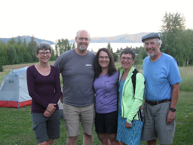 |
| Vicky, Jim, Christy, Amy, & Steve from Wendy's yard |
 |
| Ready to depart Wendy's: Steve, Vicky, Amy, Scott, Christy, & Jim |
Scott joined us for what was easily the best breakfast of the trip which Wendy fixed: huckleberry pancakes, bacon, and eggs. I thought Adventure Cycling had a map of the route, but that's not so. Christy had plotted out a map to soon get us off combined hwy 2 and 95 which are busy highways here. So we enjoyed rolling hills through the timber and occasional hay fields. These back roads led us to a closed bridge which workmen were just starting to tear out. Jim talked them into letting us cross it, but soon the pavement turned to light gravel. A couple people weren't comfortable riding any gravel, so we had a lunch and hiked about 1/2 mile to these falls while contemplating the route.
 |
| Vicky, Chisty, & Amy at our first waterfalls |
The gravel road was providing views like these.
 |
| Christy just before the turn around |
 |
| Amy just before the turn around point |
With intermittent light gravel/pavement predicted for the next five miles the group had to decide whether to 1) continue on with great views in much shade, 2) backtrack adding about 10 miles onto this first and longest day of the trip, or 3) split up for the rest of the day. We chose to back track on this hottest day of the mini-tour adding those roughly 10 miles and a killer hill climbing out of Bonners Ferry. Back on the highways traffic was heavy but began to lessen after US 2 turned east, and was pleasant after we turned off US 95. The heat and that climb out of Bonners Ferry sapped everyone, and I, a rather slow rider, found myself in the lead much of the rest of the day. I saw Jim's character master his tiredness as he forced himself on the remainder of the day.
 |
| Vicky making it across the Canadian border |
We were probably all ready for the day to be done by the time we reached the border, but the highway was mostly flat into Creston with a short killer hill that awaited us on the final climb to Scotty's RV Park. Most of the group pushed up a part of it. The camp was clean and pleasant. We met two tourists from Spokane there, the LaVoie sisters, whose campsite was in the middle of the 3 sites we had. They made pleasant conversation and gave us a bit of info on what lay ahead.
 |
| The LaVoie Sisters from Spokane: Britta and ? |
Day 2: Tue 10 Jul 2018
Creston, BC to Crawford Bay, BC
47.7 miles, 4:26 riding time, 1995 elevation gain
Just outside of Creston, BC we caught up with Gerald part of a 16 member Adventure Cycling group doing the same ride with a few extra options over 11 days. He made interesting conversation. The heat of the prior day was gone, but soon a drizzle started that would last all day interrupted only by occasional hard showers. Mosquitoes were horrible this day. Soon we caught Matt and his uncle Norm and a hard rain hit just as we were arriving at a gazebo where we sought shelter from the rain but found many mosquitoes.
 |
| Matt, Gerald, Norm, & Steve seeking shelter from the rain but finding mosquitoes waiting for us Mosquitoes were so bad the group refused to stand sill for another photo taken with the flash manually turned on |
The A/C group had planned to camp where we had rented a chalet, but after riding all day in the rain, they rented chalets. I suspect we all missed some beautiful sights today as rains make people put their heads down and peddle without looking up although we were riding beside a beautiful lake. The chalet was a welcome treat with very comfortable beds.
 |
| Jim, Christy, Vicky, Scott, and Amy preparing to leave our chalet |
.
Day 3: Tue 11 Jul 2018
Crawford Bay, BC to Nelson, BC
24.4 miles, 2:11 riding time, 1,706 elevation gain
The group was ready for a short day to fully recover from the exertion of day 1, and Nelson is a great place to spend some time. The hill between Crawford Bay and the ferry was bigger than we'd anticipated, so we barely made the departing ferry. Most of the Adventure Cycling crew was on our ferry though they had left the two assigned cooks and the sweep to catch the next ferry roughly two hours later. Traffic after the ferry was light, but picked up from somewhere and was heavy by the time we reached Nelson.
 |
| Jim nearing the top on the ride to the ferry - photo by Christy |
 |
| Jim & Christy on the ferry |
 |
| view from the ferry |
 |
| Jim, Vicky, Christy, Amy, & Scott on the ferry |
The LaVoie sisters had advised us to seek a campground near downtown Nelson which turned out to be a great location although it was cramped enough no one could use his tent fly.
 |
| our crowded but much appreciated campground in Nelson, BC |
 |
| looking down on Nelson's street fair - photo by Christy |
We arrived early enough and on the right day to catch the downtown farmer's market & street food fair. After eating lunch at the street food fair, we had dinner at the Main Street Diner which in my opinion was the best dinner of the trip. The campground's covered pavilion was one of the cleanest I've ever enjoyed on tour.
Day 4: Wed 12 Jul 2018
Nelson, BC to Metaline, WA
57.3 miles, 5:20 riding time, 3,202 elevation gain
We faced a steep hill out of town and a busy highway though a complicated road system that on the map looked much like a large clover leaf. Once at the top of the hill, traffic was light, and it was slightly downhill to Selmo, BC where I spent the last of my Canadian cash and then not many miles to the US border. We were on day 4 after an easy day 3. Using mostly my no international fee credit card had worked well for most expenses plus the rough $5 in Canadian change a friend had given me. There was a 2nd hill up to the US boarder, but this didn't really tire anyone, and the custom's agents on both sides of the border were much more friendly than those on Idaho hwy 1 where we had entered Canada. This was an incredibly beautiful day but I took too few photos.
 |
| Vicky at a roadside waterfall about where the steep climb out of Nelson ends |
I swam in the Pend Oreille River off the boat docks in Metaline, and the rest of the trip we'd be following the Pend Oreille's river valley.
Day 5: Thu 13 Jul 2018
Metaline, WA to Penny's Place on the Water near Newport, WA
55.1 miles, 5:41 riding time, 1,394 elevation gain
We picked up Scott at his "resort" a few miles south of Metaline and continued down the highway to Ione where a full grocery store gave us the option of buying dinner supplies for the stay at the rural Penny's on the Water. The highway was so quiet this morning that it seemed to matter little when we switched to the north side of the river with its ever so quiet county roads.
 |
| Brian a west bound x-country cyclist starting his final state on the Northern Tier |
Soon I met Brian starting his final state in a combined Trans-Am Northern Tier route. Oddly, no one else stopped to greet him in what looked like an excellent spot for photos.
 |
| Scott passing by |
 |
| Amy with the Pend Oreille River in the background |
 |
| my failed attempt at a close up of Jim & Christy riding by |
 |
| Steve - photo by Brian |
As the group rode by, I missed Vicky entirely. We took a brief break at Panhandle Campgrounds where Christy and I had camped on the Northern Tier, and were then off to Usk where we had lunch in its convenience store/hamburger shack.
 |
| The Pend Oreille River from the bridge going into Usk |
We thought we could avoid getting on the state highway for a mile or two at Usk. That route led us back to another lightly graveled road which we rode until it rejoined the highway, and it was up the highway until Penny's Place on the River where we swam and rested on the beautiful lawn.
 |
| Steve after a swim - photo by Christy |
 |
| Vicky enjoying the rest at Penny's on the Lake - photo by Christy |
 |
| the group- Steve, Amy, Jim, Christy, Vicky, and Scott - photo by Jim |
 |
| sunset at Penny's on the water |
Day 6: Thu 14 Jul 2018
Penny's Place on the Water near Newport, WA to Post Falls, ID (Sandpoint for everyone else)
58.9 miles, 3:28 riding time, 2,207 elevation gain
 |
| breakfast at Penny's on the Water: Amy, Christy, Jim, Vicky, and Scott |
 |
| departing Penny's on the Water, Christy, Jim, Vicky, and Amy (Scott is in the lead somewhere) |
Back to the highway and into Newport, then onto Adventure Cycling's Northern Tier route which soon had us on back county roads. There I left the group to ride into Sandpoint as I headed to Post Falls where my nephew lives.
Great trip everyone. Thanks Christy for planning this out and inviting us all!
Happy Cycling for fun, fitness, and transportation!
Steve


