18 May 2010

A week of Mountain Biking in Moab 2010

Doug and I had planned on riding Utah Cliffs this week, but with too many miles over 10,000 ft, the cold spring we’ve had, and Adventure Cycling’s recommendation that ride not be done until June to allow for the spring melt, we made a last minute change to ride in Moab.  My packing was chaotic- when I had mostly packed my panniers, we switched destinations, so I finished packing using a suitcase in addition to the panniers.

We had no reservations for night one, so we found a spot at the dusty crowed, and small site (10' x10' tent spots), Slickrock Campground.  We were both glad to escape that and move to Moab Valley RV, where Doug had reserved a cabin for our first few nights.  That stay was made more enjoyable with the presence of 20-some cyclists from the Sacramento Cycling Club.  One of their members had suggested a trip to Moab, and 20-some agreed to go.  They made for pleasant conversations in the mornings and at the evening hot tub sessions.

Moab, the very word is almost intimidating to a casual mountain biker like myself but since long ago when John Arland taught me what I know about mountain biking, it has intrigued me. A day by day description follows.

Day 1  9 May 2010  
48.6 miles  5:14 riding time 
Court House Loop (Bar M/Coopers Ridge to Sovereign Trail and Arches National Park)

Doug had purchased Rider Mel’s Mountain Bike Guide to Moab which we’d use to plan our daily rides.  Day 1's route took us over the bike bridge on the Colorado and north to Bar M Trail.  The weaknesses of the book were soon evident- Bar M trail seemed to turn into Coopers Ridge trail- which our book didn’t even mention.  When the trail turned south while the map showed it continued north, we knew something was wrong.  Cooper’s Ridge trail went our direction, so we decided to try it.  We soon met a couple that confirmed we were on the right path- Coopers Ridge and Bar M merged for a while- and those who put up the signs simply alternated signs for the two trails that temporarily overlapped.  Our book also failed to mention the Sovereign Trails which we’d turn on next, but despite these flaws, the book remained our best asset for planning routes- it just left out a lot of detail and seemed out of date.  Our route over single track and jeep trails took us into the back side of Arches National Park- with a lot to see.  Traffic on the park’s highway was fairly heavy with no shoulder.  A good source for pre-planning might be http://www.discovermoab.com/biking.htm, to select routes and then buy specific maps.

Doug climbing the abandoned road up to Willow Flats Rd


Doug still climbing

First view of the Arches

Doug in front of an arch

Doug at our cabin at Moab Valley RV which I was glad to switch to


Day 2 10 May 2010 
Porcupine Ridge
31.3 miles riding time 5:44

The ride through Arches National Park provided some nice trails and was a great introduction to the Moab area, but it isn’t what made Moab the destination for mountain bikers.  Porcupine Ridge is much closer to that, and provided some challenge to my skills and my hard tail.  The route took us up the steep Sand Flats Road where we met a mid-west guy all psyched up to be in Moab- he’d finagled this trip as an addition to his daughter’s college graduation somewhere in MT.  This biker had bought his wife a new bike, but she didn’t know how to shift.  Moab has something to offer almost anyone- but maybe not those learning to shift. While his wife slept in he’d just made his first Moab ride on “Practice Trail” somewhat misnamed.  It’s more of test of one's skills on a short trail to verify the existence of the skills that might be needed in Moab than a beginner’s practice route.  Practice Trail will come up again in this blog. 

Steve where Porcupine Ridge Trail leaves Sand Flats Road

A few miles up the road we entered Porcupine Ridge. I was surprised how my lessons from Arland flowed back as I rode this rather technical trail.  It is full of famous “slick rock” which isn’t slick at all- it’s a rather sticky sandstone.  On the mountain sides this rock is often in almost cut sections forming small stairsteps- some 3" high and some 3 feet high.  It’s easy to climb the short stairsteps- do a bit of a wheelie, and power the back up.  Going down them let me better understand the term “hardtail”- the back end of the bike jumps up hitting the cyclist’s butt.  At the top we enjoyed some great views, and we met a group that had been shuttled to the mountain top. The trail’s about the width of a jeep trail- even when jeeps aren’t allowed.  The readily seen tracks of most cyclists take the easiest route over the “slick stone drops”.  However, when the first guy was rapidly gaining on me, I pulled to the unused side to have him pass me with about 2" of clearance.  He was going for the highest part of the drop- whether I was in his way or not.  A few minutes later I was completely off the path when another speedy descenter exclaimed “Oh man”, as he looked back to see he’d ridden off a 3" drop when he could have ridden over a 2' drop!  Everyone who passed me seemed to be interested in riding the biggest drop, and, of course, they were all on full suspension bikes.

Doug where the trail almost looks like a road


Doug climbing- the trail is losing its road like appearance
Steve enjoying the view at the top

Doug - another view from the top

About a mile from the bottom, the trail seemed to end as it crossed a deep ravine or side canyon, and after the ravine, there were many rock slides making it a more of a hike-a-bike down to the Colorado River, where we alternated between a bike path and the highway back to Moab.

Steve crossing the side canyon - photo by Doug
Steve nearing the Colorado River
The Colorado River is in view - photo by Doug


Day 3 11 May 2010
Hurrah Pass toward Chicken Corners
51.2 miles 6:19 riding time

After yesterday's Porcupine Ridge, we decided to do something less technical- like primitive roads, Hurrah Pass.  This took us down the Colorado River for a few miles before crossing a big steep ridge into a side canyon with some dramatic scenery.  Down that draw for several miles and then back over Hurrah Pass to the Colorado River toward Chicken Corners.  This put us in some sand- which surprisingly enough I enjoyed.  This sand was course- and with some effort in a low gear could be ridden through.  I should say I enjoyed small stretches of it- the 30 feet or so I could get through.  I could feel the front and rear tires going separate ways, but with a quick effort in a low gear I could keep the bike upright and moving forward. This skill applies only to the course sand; I never learned to ride through the powdery sand found elsewhere. We turned around because it was getting late, but we had fought headwinds all the way down, and we’d have a rather rapid return with a strong tailwind. With the dramatic scenery and steep climbs, this was my favorite day.

Doug on the road
 
Doug

Steve at the top of Hurrah Pass

Yes, the rocks are this red


Day 4 12 May 2010 
Fins &Things
30.3 miles 4:54 riding Time

I suppose the choice of this trail was my suggestion.  It was up the Sand Flats Road to the beginning of Porcupine Ridge- but we’d descend instead of ascend.  I found the first section a bit scary.  The upper section of Fins & Things had the drops of Porcupine Ridge, but it was littered with loose dirt, sand, and rocks!  Fortunately, that section didn’t last too long- the loose dirt was gone and the loose rocks decreased in number.  The scenery wasn’t as dramatic as Porcupine Ridge, but the fixed rock formations were similar.  Then we got to the lower section- where large slickrock dominated.  Oddly, Doug didn’t like the slickrock at all.  Some of it was steep we had to ride over large boulders and there were sand traps between them. Doug didn’t enjoy this terrain. He was slowing down, and at the steepest rock he declared it was too steep to even push up, so we walked around a large boulder looking for a less steep route over it, and then we couldn’t determine where we had been!   On our behalf, there were trails up the boulders in every direction.  Then we saw cyclists at the top of a boulder maybe a ½ mile away.  Doug favored going cross country to meet them though there were plenty of ATV’s where we were.  So it was cross-country to find moving cyclists in the desert!  When we got there, they weren’t there, but others were.  We were now somewhere in the middle of “Practice Trail”, that somewhat misnamed trailed we’d heard about on day 2.  We were also very close to the lower end of  Fins & Things where it meets Sand Flats Road.  Knowing he was nearly out of the slick rock, Doug forgot his tiredness, and took off.  It wasn’t long until I caught him in the parking lot.  I enjoyed the slickrock though and would like to ride it again.

The top section of Fins & Things rides rough like the roughest sections of Porcupine Ridge, but it lacks that spectacular beauty.  Steve not too far below the Porcupine Ridge trailhead- photo by Doug


the desert view from the upper portion of Fins & Things
 
Doug on the lower section of Fins & Thing when it gets into slickrock


Day 5 13 May 2010 
Two Tortoise Rock via Bar M & Coopers Ridge Trails 
47.6 miles 6:30 riding time

Choosing routes is a bit of a challenge, but today we decided on Two Tortoise Rock- which would take us out of town on bike path and Bar M trails again, and then over a small mountain for more dramatic scenery.  Most of the route was on dirt roads- with moderate traffic when we were used to almost none.  At the point we met 15-20 pre-teens mountain biking (see photos) we turned up a steep road which deteriorated into more or less a jeep trail that did a circle and ended up back here again.  About the mid point in the loop the trail deteriorated with a lot of sand and some of that slick rock I like.  Nonetheless, there was too much sand for me, and Doug likes sand less than I do.  We were both glad to finish the loop and be back on firm ground. 

looking back at our route in

 
the pre teens are arriving!

view from somewhere on the loop


Day 6 14 May 10 
The Green River- Mineral Canyon Rd to Taylor’s Canyon
47.8 miles 5:15 riding time

Doug and I both prefer riding without motorized assist of any kind, but we’d decided on driving to where the Mineral Canyon Rd meets the highway.  That left us with probably 12 to 15 miles of riding on smooth clay roads to the top of the canyon and a steep descent to the Green River, where we met several college age girls starting up this steep road.  All were friendly except one who was a florescent red, probably 75 pounds overweight, and who refused to speak or even look us in the eye when greeted.  The college boys were back on the Green River enjoying a swim.  We asked the driver of their support vehicle how many he thought he’d be transporting to the top.  It seems this was a class, and he was clear he wasn’t picking anyone up, though he predicted how many would have to push!  Perhaps that non-speaking gal had gotten herself into more of a recreation course than she’d realized.  We rode down the Green River to Taylor’s Canyon and tried crossing it and going up it.  Both ways were too sandy, so we turned around.  The college kids were gone by the time we reached the top of the grade, but we met an extended family there with many pre-teen kids planning on a 100 mile ride through the area over 4 days.  The ride from the top back to the pickup was a bit dull, no big hills, no interesting sandstone formations, just a high plateau- 12 miles.  It’s amazing how dramatic terrain can spoil a person, so 12 miles of plateau becomes boring!

the road down to the Colorado
Doug speeding down to the Colorado River


That night was different.  The friendly mountain bike club from Sacramento was gone, and a rain storm arrived early in the evening, forcing us into our tents by 2000 hours.

Moab offers interesting riding for cyclists of almost any ability- though one needs to know how to shift before going!  Porcupine Ridge started me thinking of a full suspension bike.  I am set up for a Hut to Hut ride of a week through the mountain between Durango, CO and Moab later this year!  It was 8 ½ hours of driving back to Boise.  Maybe I’ll make this trip again! I returned in 2016.

See Doug's Blog:
Doug's Perspective part 1
Doug's Perspective part 2 

Doug's excellent photos


Return to Moab in 2016


His photos are the best!  I opened a Picasa account thinking I could add photos, but the process is just too complicated.  My few photos .  

Happy cycling for fun, fitness, and transportation!


Steve

24 September 2009

Shadowing Cycle Oregon 2009

Cycle Oregon 2009 had filled up without us, so Doug and I decided to follow them by a week  using their maps.  We met some of them finishing up as we were starting on day 1.

Day 1 19 Sep 09 Gold Hill, Oregon to Yreka, CA 81.2 miles 6:51 riding time
My internet search for campgrounds took us to the KOA campground in Gold Hill, about 14 miles out of Medford, CO's (and therefore our map's) starting place. Starting in Gold Hill added to the first day’s mileage and reduced the final day’s distance, and the facility turned out to be clean and had a swimming pool. Doug arrived just in time for supper at a Mexican restaurant down in Medford. Each day we arose at first light of dawn instead of the CO routine of arising earlier, having breakfast, and returning to take tents down at first light of dawn. About 14 miles into the trip we passed through Jacksonville, where the first pace line of the day from Cycle Oregon caught us, calling out the familiar “on your left” as a truck was passing from behind. Maybe there are advantages of cycling the route with just a group of friends! A couple more groups in a hurry to finish CO that morning passed us before we turned south on our shadow ride. None of Ashland’s shops caught our eye as we passed through, though the architecture was interesting. Since we weren’t supported by those wonderful “ODS” stops, we stopped at Albertsons for grapes and apples, and Doug picked up a subway sandwich which we stashed in our panniers. As we climbed our first mountain, we passed a local cyclist who gave his highest recommendation to “Callahan’s Restaurant”. Great food there; far surpassing any Cycle Oregon lunch I’ve ever had. “Maybe we didn’t need all that support after all”, I thought as we made the final short assault over the mountain into California. Here we got on the freeway for a few miles. We might have gotten on the freeway about a mile earlier than the official party, and that first mile was a bit nerve wracking as road construction had our side of the freeway restricted to one lane- fortunately we could ride on the right side of the traffic cones. Then it was a rapid descent down the California side of the mountain. We enjoyed our afternoon snack of fruits in the lawn of the same rural school CO had used, and we cycled on into Yreka, where we found the newly built “Yreka Travel Plaza”, a new RV park with flat well manicured grass perfect for our needs. Dinner was at “Grandma’s Kitchen” where Doug made some special request, and the waitress’s answer was “this is Grandma’s kitchen, of course, you can have whatever you want”. Maybe we really didn’t need all the CO support! 
Steve climbing the Siskiyous Mountains south of Gold Hill, OR - photo by Doug

Steve arriving at Willow Creek School Lunch Stop - photo by Doug


Day 2 20 Sep 09 Yreka, CA to Happy Camp, CA 83.3 miles 6:51 riding time
It was downhill nearly all the way as we followed the Klamath River to Happy Camp watching the flora turn from semi-dessert to almost coastal forest. A turn of the last century building housed an extremely efficient little eatery where Doug and I had homemade coconut cream pie and met some BMX’ers who are students at a bicycle repair or building school. Down in Seiad Valley a good hamburger or chicken sandwich was our lunch. Lots of motorcyclists enjoy this road, but they and many state police seemed to be the only real traffic for the day. As we entered Happy Valley, Doug noted a sign that read #1 Rated RV Park in the West. That’s where he wanted to go though I thought we should check out the city park and I would have stayed in the USFS Campground on the edge of town. Showers were available at the laundromat, and the Klamath River looked good for swimming. Doug had decided he wanted a hot shower in the #1 Rated RV Park in the West”, so we rode up the hill which required my low gear of 20.6" - which is low enough to give me bragging rights in most touring groups- but I prefer to brag about having it- while never using it!! The other side of the hill is just as steep, but it turns into washboards and gravel for the descent! The entrance to the office was a rickety wooden steps that appeared not to have been swept in several years. An older woman who seemed to be quite indifferent to our staying there met us, and I thought we might escape to the USFS campground nearer to town, but a very friendly tenant showed up greatly excited for us to stay there. He showed us to a somewhat flattened but dusty site where we could erect our tents. The RV park was, in fact, a trailer park with at least one double wide; most of the residents lived year round in camp trailers of various sizes and ages. Everything in the trailer park was covered in dust. At this point Doug was more uncomfortable staying there than I was, but neither one of us wanted to climb that hill again to escape it, and our fee had been paid. Doug smelled someone smoking marijuana. The mountain stream was extremely cold, but we both had brief swims in its nearby swimming hole and never made it into the showers. We left for dinner, and even on an unloaded bike, I needed my 20.6" gear to get over that washboarded hill. Happy Valley was once a saw-mill town but now seems to be a mixture of retired Californians from the Bay area and the chronically unemployed/underemployed. From the outside, its one restaurant looked seedy. We decided on the competition, a pizza place in the “strip mall”- a strip mall in a town with about two businesses downtown! The pizza wasn’t very good, and the place was a bit seedy on the inside. On second thought, maybe I do need that CO support! Although I slept fine in the dusty “#1 Rated RV Park in the West”, I was glad to escape it the next morning. Breakfast presented two choices: 1) eat in the apparently seedy restaurant or 2) make our own PB&J sandwiches- with no known lunch stop. Well, in contrast to the restaurant's outside, its interior was clean, recently remodeled, well lighted, and the food was good. None-the-less, Doug was happy to shake off the dust of Happy Camp from his cycling shoes!


Doug on one of the bridges

Day 3 21 Sep 09: Happy Camp, CA to Cave Junction, OR 58.9 miles; 5:56 riding time
The first 25 miles were uphill- steep, but the scenery was beautiful with little traffic. The CO maps shows 5,200 feet of climbing this day (with 4,497 ft of gain in the first 20.0 miles), but CO didn’t start out in the Dusty Trailer Park! This is incredibly beautiful country- with near coastal rainfall forest varying to the dry scrub oak forest. I’ll let Doug’s photo’s do my description of the terrain! With no towns, we had snacks later in the day than we’d have liked in “Holland” another turn of the last century country store. We altered CO’s course slightly and spent the night in Cave Junction, OR which offered all services. If Happy Camp was in the land of weird people, Cave Junction might be its capital! Doug seemed most uncomfortable with the untrimmed beard on almost every male. I was most uncomfortable with the glazed look in the eyes of so many (drug use?). Lots of them weren’t overly clean, and I decided this is where many of the San Francisco Hippies of the 1960's came and reproduced leaving a distinctive “culture”. Dinner was at “Taylor’s” a meat shop with a very clean attached diner.
Doug enjoys a quick swim

Day 4 22 Sep 09: Cave Junction, OR to Gold Hill, OR 92.5 miles 7:27 riding time
Maybe because we had left the route the day before, we missed a turn this day. I kept wanting to turn north, and suddenly Doug noticed the morning sun was in our face or slightly on the right where it shouldn't be. Although it was beautiful riding in the mountains, Doug flagged down a USFS employee to ask if we were going where we intended. His map reading skills were poor, but eventually we verified we’d missed the turn north and were headed east as the sun had told us. It turns out the turn we missed was one of those “Oregon” wonders- a one lane paved road through the mountains. It looked more like a private driveway than a public road when we returned to it, to cross another mountain. After we passed “Lake Selmac” where CO stayed we knew we were back on route, but this day’s cycling would reach almost a century in length in heat hovering around 100 degrees. As we approached Grants Pass, we had to put together portions of 3 days of the CO route although we could have chosen a closer route between Grants Pass and Gold Hill. We were hot, tired, and hungry when we arrived back at Gold Hill's KOA, and we both enjoyed a swim in its pool before driving off to the nearest Olive Garden for the Italian dinner we’d been promising ourselves since Happy Camp.
Steve on a short, steep gravel section - photo by Doug
Doug going into the detour near the CA OR border

Day 5 23 Sep 09: Circling Crater Lake 32.9 miles 3:21 riding time
A great way to spend a day. It was up and down constantly. See Doug’s photos. http://www.flickr.com/photos/doug_goodenough/sets/72157622451834674/show/
This was a great experience. I missed the ODS stops (snacks) and CO's high quality breakfasts and dinners, and inevitably meeting cycling buddies from prior Cycle Oregons. I didn’t miss the morning passing and being passed routine, the long lines at breakfast, the porta potty lines, the shower lines, and the hurry up and wait feeling that I sometimes have on CO. In as much as cost matters, shadowing the CO route came it at just under $50 a day- a lot cheaper than $125 per day for the supported ride. I knew Doug to be a faster rider than I, so I feared he might “rush” me. Not so, he enjoyed photography and looking over each town or site of interest we passed in fine touring tradition. In the future my friends could sway me either way between shadowing Cycle Oregon again or riding as part of CO as CO’s routes are always challenging, well researched, and with many great back woods paved roads as we enjoyed this year. However, most years we wouldn’t be able to cut the route short and finish in 4 days! I do look forward to reading Doug's post (we all have different perspectives) and seeing his photos!

Happy cycling for fun, fitness, and transportation!

Steve

26 October 2008

Cycling the Weiser River Trail - a Farewell Ride with the LT

Logistics: Getting out of bed at 0345 MDT was the difficult part of the new deal for me. We caravanned 3 vehicles to Weiser where we dropped off my car at the lower trail head. Chief Winn wasn’t sure of his fitness for the ride, so we dropped his car in Midvale- some 30 miles short of the goal in Weiser- just in case he couldn’t make it all the way. We squeezed bikes, gear, and people into the LT’s pickup for the remainder of the ride to New Meadows.
By the time the New Meadows breakfast was over, it was dawn (0800 MDT) and in the upper 20's in the mountains. “A balaclava and warm gloves are the most necessary clothing items for the morning portion of the ride” I had advised in that Friday morning meeting, but the LT had packed his balaclava for his upcoming move, and didn’t want to part with $9 for a low cost replacement the Chief had recommended. Neither of my companions wanted to ride the highway up the hill out of New Meadows, so we drove back to “Rubicon” that mythical start of the trail. Not finding Rubicon, we settled for what appeared to be the transition of the trail from over land to the old rail bed.

Rubicon to Council 17.7 miles 2:03 riding time : Through the Beautiful Mountains
On our first breather, the LT noticed his insulated camel-back tube was frozen completely allowing him no water. He tucked the tube into his coat hoping it would soon thaw. The Chief and I wondered about his poor exposed ears as we enjoyed the warmth of our $9 balaclavas! (I can’t find my silk balaclava this fall, but I’m not letting that fact freeze my ears!) The fall colors were striking- bright reds and yellows everywhere contrasted well with the bright blue sky in this, the mountainous, portion of the trip. Once the sun was up above the surrounding mountains, the temps began to rise. The LT’s previously frozen camel back was providing him water by the first photo stop, and thereafter he didn’t even have to tuck the tube into his coat to keep it thawed! We were all rid of our coats by 1000 MDT when the sun had begun to warm the draw that becomes a valley or canyon. Trail conditions are better than on last year’s test ride; Doug’s Slough has been removed, and I couldn’t even find where it had been. The trail was smoother, and, Corrie, no one had trouble getting through the side gates! There are still some short sections just north of Council that are rough. A doberman at the old long house on the edge of the railbed made me glad for my “Halt” though a shout at the dog caused it to stop before it got the liquid Halt in its snout! More barking but seemingly friendly dogs awaited us outside Council, so consider bringing “Halt” when you do this non-paved ride.

The LT and Steve still bundled up- photo by Chief Winn

Chief Winn


time for a photo break
one of the bridges near the Weiser River


Council to Cambridge 29.7miles 1:44 riding time: Smooth Trails

The trail comes out of the mountains just a few miles north of Council where the roughest section of trail is. That and my reading had me a bit concerned about trail conditions below Council, but the trail proved to be as smooth as the average lightly graveled road- better by far than those few desert miles into Council. Fall rains which are responsible for the current excellent trail conditions in the Boise Foothills may also be the cause for this better than expected riding condition, and it was much smoother than I expected. Corrie, the gates do get worse; most of the time there is no side gate, and a gate the width of the rail bed must be opened and shut frequently enough to seem a bother. The route remains along the river and is away from roads and people, adding to its appeal! Some of the best home made onion rings I’ve ever had as well as ½ pound hamburgers were served in a little restaurant,  Mrs G's, in Cambridge. The LT had a double half pounder- which of course equals a full pound of beef with a big side of fries- before continuing on the ride! At 23, I suppose one can eat anything! Some of you may be accusing me of teaching him how to eat on tour, but that would not be true. While the food was excellent, it might not be “high in carbs” that most of us cyclists are seeking!

The LT and Steve at one of the many small bridges

Old bridge- photo by Chief Winn

Cambridge to Midvale: 9.6 miles 46 minutes riding time: A Puncture Weed Lesson
The route continues to follow the river, and is generally away from other roads and civilization’s noises. Temps had risen so that we were all in shorts and “T” shirts for this section of the ride. For a short way there was a farmer’s field road adjacent to the railway. The LT darted over to it with its few rises and obstacles. It looked fun, and I almost joined him before a flashback to puncture weed lesson #1 hit me- don’t leave the trail in desert conditions. I watched him bounce around and then depart the field road dropping off-trail into a small gully before bouncing up onto the railbed again. By the time we reached the next bridge, he had a flat rear tire. He flipped the bike over and found a couple goat heads. He thought he had slime, and that by pumping a bit more air into the tires he could ride off like Chief Winn had done earlier in the day up in the forest before we entered goat-head territory. The tire kept going flat, but then he’d find another goat head, pull it, and refill the tire! During this process, I found a couple goat heads in the front tire, so we started this same process. We became suspicions he didn’t have slime; he didn’t. We’d have to use his replacement tube plus mine. Turns out, he wasn’t carrying a replacement tube or patch kit! I thought I’d trained him better than that! The chief’s spare tube was presta, which was of no value to us. So, it was off to the river with the tubes to see which tube was worse. The chief, who had just had a horrible experience with puncture weed, sat up on the bridge pulling 20 some thorns out of the inside of the tires with the tweezers he had wisely brought for such an ordeal. I found 5 rapid leaks in his tube assigned for my review and thought there were a couple more slow leaks, but it’s difficult to count when there are so many and the red pen is resisting writing on the cold wet tube! The LT said the tube he was looking at was worse, so we crawled back up to the bridge to begin the patching of the tube I'd inspected. I didn’t have enough patches, and the LT had none! Fortunately, the Chief, who was paranoid after his recent Devil’s Slide type experience, was carrying two new patch kits which were purchased just for this trip. When the five identified holes were patched, the LT asked if it was really necessary to crawl back down to the river to verify the work. All I said was “it’s the smart thing to do”. Fortunately, he crawled down to find one large leak I’d missed, and a small one we would ignore. Patching that tire took an entire new Rema patch kit, and we still had a slow leak that we were ignoring! A lesson for a long time cyclist!

The LT filling his newly multi-patched tire
 
After we rounded the next corner, we could see Midvale’s water tower off in the distance, and the chief who had been slowing down was off like a tired horse that had seen its barn in the distance. The LT and I struggled to keep up. He yelled “barbed wire”, and I slowed just a bit though I did not see it. Then I felt a jerk on my left peddle. The LT said the wire went taunt as it grabbed my peddle, and I continued down the trail. When I felt that jerk, I nearly went down. Fortunately for me the wire had grabbed my peddle without grabbing my body, and it let go under pressure. A new piece of wire that still tries to wind itself up and is attached to something can be a hazard far beyond a flat tire! A 2nd lesson for a long time cyclist!
 
Midvale to Weiser Approximately 25 miles and estimated riding time 2.5 hours
I loved being away from the roads and noises of modern life, but this next section would take us into “roadless areas” that are some 10 to 12 miles from the nearest road. With no spare tube and just 3 patches between the two of us, I wasn’t eager to head on down that isolated trail. Patching a tire at dusk or later would be impossible for me though the young eyes of the LT might see some hole in a black tube at dusk. Still it was 1700 hours leaving us two hours of good light (MDT- what a blessing!). We had brought lights along just in case some challenge caused us to arrive after dusk, so we were prepared for that. The idea of another major run-in with puncture weed with no spare tube made me unwilling to finish. I think the LT was most disappointed. He was in shape for the 80 miles and looking forward to his longest ride ever- though it was a downhill ride! The Chief adds that none of us were the least tired, and we all could have easily completed the ride had it not been for the flat tire issues!


Disclosures:
1) All the TRC’s who had wanted to do the Weiser River Ride last spring were invited to join us. None did.
2) I’ve been forgetting my camera this summer like some Laurel and Hardy routine. This time I put it in the pannier and then took it out to change the batteries, and then put the camera beside my bag where it was sitting alone when I returned. Maybe the other guys will provide some photos that Corrie will add to this post, but Corrie may have grown weary of my helplessness in this area!
3) Army pilots don’t like the title “Chief”, but I used it anyway as Mr. makes him sound like someone from my father’s generation instead of a guy a couple years younger than I.
4) Puncture weed is at its very worst just after fall’s first heavy frosts which means right now.
5) I’m really going to miss the LT as he heads off for nearly 2 years of flight school! He’s been a fun and adventurous companion this summer.
6) I’m willing to do this ride again, and Chief Winn and I may do that final section soon, but only with many spare tubes in our possession!

Originally posted on 26 Oct 2008 on Free Conversant

28 September 2008

Climbing Mt Borah - I Was Lied To


The deal with 2LT Klein was- he'd mountain biked to Silver City with me over Labor Day I’d hike up Mt. Borah with him later that month. Payment in full came due on 27 Sep.
We drove into the full campgrounds Friday night at the foot of Mt Borah. With no sites available, we found a relatively flat spot at the side of the road where we were establishing our camp when “Mike” a gregarious 60 pound overweight climber walked up, introduced himself, and told us there were several flat spots near his camping site where our tents would fit. By 0700 MDT the next morning Mike had breakfast and was gone, so we were able to use his table for breakfast.

“It’s 0816- we’re 16 minutes late departing” the precise 2LT announced as we left the 7,200 ft campground starting the 3.5 mile hike up to the 12,066 ft highest point in Idaho. The 2LT is a mountain climber- he’d reviewed the books on the climb and had his “ice pick” and walking stick with him. He had wanted to bring his ropes, but he knew I was going nowhere that required ropes and his reading said they’d be no need for them. “This is a Class 3 mountain” meaning the most difficult portion would be a scramble (using all four limbs to climb) up the steepest ridge “Chicken Out Ridge near the top", he reminded me. I trusted the 2LT’s research but had briefly reviewed one of his books to see that it supported this definition- which it did. After the first 1,000 feet of climbing (or hiking) we took breathers at every 500 ft gain and the 2LT would remind me we were to take short steps so as not to tire out. Despite the many short breaks and short steps, we kept passing people, and no one passed us.

Had the previous night’s camp been touring cyclists instead of climbers (or hikers- I still don’t know which word applies) we’d have all wandered into each other’s camp, learned where everyone started and planned to finish his tour, compared equipment, and discussed the best places to eat found on that tour. The climbers weren’t that social, but we did speak when we passed and pace and elevation seemed as prevalent a topic as it would have been among cyclists. I was surprised at the overall lack of fitness among them. Mike with my estimated 60 pounds overweight was the heaviest, but many were obviously overweight. The sign at the bottom of the trail had advised allowing 12 hours for the trip, and with the recent passing of fall equinox, that’s just a bit more daylight than we have. I’ve been caught by nightfall before on bicycle-tours (with lights), and I had no interest in being on that mountain at night. Between the time of the Silver City Ride and this climb, 2 Boiseans had spent the night on Mt. Borah without coats or lights after climbing it that day. I had no desire to get the news coverage they had generated; the news was they "survived".

By 1100 hours the climb turned into a scramble. With only 1 exception handholds and footholds were easy to find, and it was a fun scramble, but I did have to concentrate on looking up, finding those holds, and refusing to look down. “Ah, I’ve made the scramble”, I thought, “that wasn’t too bad”. Next thing I know I’m straddling a narrow ridge- 1,000 to 1,500 ft straight down on one side, and nearly as far down on the other- but there are a few obstacles to hit if one falls that direction. I freeze. The 2LT wonders if “he” can get me down! I have a flashback to the one spot that was difficult on the scramble, and decide without any remorse, that I’m going back down. When I arrive at the “difficult” spot in the scramble, it then seems easy to descend, and fear starts rapidly leaving my body. (I admit I like to be high and safe, and look straight down- from safely behind some well engineered safety fence. I enjoy that little spike of fear. This fear was not like that!) I knew the 2LT had been looking forward to this climb for sometime, and even when I announced that fear had the better of me, part of that sentence was a request that he finish the climb. He thought he could reach the top and be back within an hour. A single climber arrived just then, so the 2LT teamed up with him; we soldiers take the “buddy system” seriously, and this 2LT is a soldier's soldier. I found a nice spot somewhat isolated from the wind, and enjoyed my lunch. It was a great place to talk to the climbers and observe just at the bottom of the scramble. Most of them we had met on the ascent. There was the father son team (ages 60 & 30 I’d guess). The father’s steps seemed weak and wobbly to me even before he started up the scramble. I expected to see them again in a few minutes, but I was wrong. Then this 30 year old 30 pounds overweight guy shows up. He’s flushed and wobbly. His companion had left him behind. I thought he might wait with me at the bottom of the scramble, but he went on. Turns out his companion is acting as the 2LT’s temporary buddy and the 3 met somewhere near the top. Mike, our overweight campground friend, arrived tired, red, but still friendly and talked about 15 minutes though afternoon was progressing. He thought I’d chickened-out on “the edge of the knife” rather than “Chicken Out Ridge”. Turns out there are 3 of these ridges to cross. He assures me next time I come, I will be more acclimatized and used to the mountains, and will likely not Chicken out. I’m very glad I chickened out where I did.

I met my Waterloo where indicated.  I was supposed to walk along that narrow ridge which is where I "Chickened Out"
.
The 2LT’s estimate of an hour to the top and back was wrong; it took two hours. I descended a bit more and found smooth wind-protected rock that caught the sunshine and took a little nap which let the last vestige of fear depart my body! It was beautiful up there. The mountain is much more impressive from the top looking down than from the bottom looking up! When the 2LT arrived, he had a bit of altitude sickness - dizziness, headache, stomach-ache. What a pair we’d have made had I overcome my fear and gone on- the fear-paralyzed led by the dizzy disoriented! At 1430 we headed down, and tired people were still headed up. In addition to the well publicized duo that recently survived the night on the mountain without so much as lights or coats, over time 7 people have died trying to climb Borah. By the time we reached the bottom just after 1700, my quads were screaming at me to stop descending and my feet had eventually joined in the chorus. From the fitness level of many climbing the mountain and their disregard of time, it seems a wonder that “news” isn’t generated from Mt. Borah daily.
The LT at the top

It was fun to try a new sport that bicycling seems good training for although my quads are stiff and the muscles in my feet a bit sore today (both from the descent), but the challenge, beauty, and experience made it worth it. I no longer owe the 2LT a mountain climb, and I’m always glad to have a debt paid-in-full.

A Chicken at Chicken Out Ridge

Steve

Free Conversant where this was originally posted has been shut down, so I've reposted here.  Originally posted 28 Sep 2008 

31 August 2008

Bicycling to Silver City- An Adventure with the New 2LT

Murphy to Silver City with some mountain climbing
33.8 miles 5:20 riding time
Sat 30 Aug 2008

Back before The Bank sold out (pre 1995) moving me to North Idaho a friend had suggested an adventurous ride from Murphy, ID to Silver City, ID and on to Jordan Valley, OR to spend the night in a motel returning the next day. That friend quit bicycling while I lived in Lewiston, and I hadn’t found an adventurous partner to join me though I’d never given up on the idea.
That is until this summer when a young 2LT was assigned to work with me while awaiting his orders to flight school. Though his riding had never been too serious- around college campus- our rides in the foothills saw his fitness and love of the sport steadily improve and soon we rode over Shaw Mountain and to the top of Bogus Basin. I should have been warned of trouble ahead by his mountain climbing attitude (yes, that’s his primary sport) that showed itself on those last two rides. He can’t stand to ride to the top of some mountain road and see that we’re not at the very pinnacle of the mountain; he must reach the top. On Bogus we had to do the trails to the top of the highest peak, and when that ended some 30 feet below the highest rock, we were soon climbing that rock! Though he has an adventurous spirit and is enjoying mountain biking more every week, he did extract a promise from me as the price of his riding to Silver City. I have agreed to hike (I hope) or climb (I hope not) to the top of Mt. Borah- Idaho’s highest peak- with him later this year. (I have seen it from the safety of the nearby highway, and it doesn’t look too steep!) Maybe his orders for flight school will arrive this next week making him unable to honor our agreement!

The old plan had called for riding unloaded bicycles to Jordan Valley, but I had mentioned to Will we’d have better options if he had panniers and a tent. When he showed up at my house with newly purchased panniers and a “hang off the seat post rack” (not the rack I’d recommend for touring), I quickly repacked with tent, sleeping bag, and thermarest. We drove to Murphy, the Owyhee County Seat, with a population of maybe 500. Though it’s not far from the Snake River, it’s in the dry unirrigated desert. The highway climbs steadily for 4.7 miles out of the Snake River Canyon, and then the route turns to continue climbing to the base of the Owyhee Mountains. What a reminder of the route from NV to Death Valley of last February. When we reached the base of the mountains, the similarity ended as did the rocky pavement. 

Owyhee County is desert country, and the Owyhee Mountains rise out of the sandy desert while retaining sand and decomposed granite as its soil in addition to the basalt rocks that rise above the surface everywhere. The sand and decomposed granite make for a road surface that lacks traction. That said, it’s a pretty good surface compared to the gravel and sand mix we found in Death Valley! However, it’s very easy to spin out almost anywhere. The road surveyors didn’t look for the most direct route, or a route following streambeds. It is constantly up and down- though mostly up- on the way up to Silver City which is over 6,000 ft elevation.


The 2nd LT at the top of New York Summit

 We arrived in Silver City about 1:30 just in time for lunch at the hotel; hamburgers were basically the only choice. The 2LT wanted to set up camp in the nearby campground and ride to the top of the surrounding mountains without packs., Dinner at the hotel was by reservation only, and they recommended making those reservations 2 weeks in advance. The small counter of candy didn’t plus the limited food we had brought wouldn't make for a decent dinner. Lucky for us the hotel had a couple of extra salmon steaks, and if that’s what we wanted for dinner, they’d accept our same day reservation. Salmon was just what I had in mind- especially given the alternative of PB&J sandwiches I had brought, and the 2LT had only power bars! We walked around town seeing the sights http://www.ghosttowns.com/states/id/silvercity.html, set up camp, and then the 2LT had me climbing the mountains on my mountain bike up to 7,200 ft, I believe his Garmin reported. Only about a 5 mile round trip to the top of the nearby mountains, but boy were they steep- rugged and beautiful too! With only 33.8 miles for the day, I felt like I’d done a century, and not an easy century! Our camp site offered no showers, so I was off to the small swimming hole in the center of town- only about 3 ft deep and as cold as you’d expect an over 6,000 ft mountain stream to be, but I could submerge, and it got me clean before dinner! The 2LT, being somewhat adverse to cold water, settled for baby wipes!

Dinner was a very pleasant experience- fine dining in Silver City was a surprise- excellent food and I believe they achieved the family atmosphere they are striving for! The staff had a lot of admiration for our bicycling up- which may have been the reason our last minute reservation was accepted, and they all treated us very well (in contrast to the Death Valley experience!). 

The adventure continued even that night. Our nearest neighbors were flying Confederate flags, had their own “terminology” calling people they didn’t like “Yankees” among other distinctive terms. I wouldn’t have noticed this, but around midnight, they were drunk and started firing their pistols in the camp which continued until about 2:00 a.m. when a local property owner drove up on an ATV, and advised them to stop, or a deputy who had called him from Murphy would be dispatched, and after driving all that way would take someone back with him to jail! Now, in fairness to the South, I must add the license plate on the king cab pickup was from Washington State, none of the several participants had even the slightest Southern Accent, and their drunkenness, words, and actions, would have greatly offended fine gentlemen like Robert E. Lee or Stonewall Jackson!

Oddly, I awoke this morning feeling like my rump had been bruised on one side. Careful inspection reveals no saddle sore but nonetheless, the area wouldn’t tolerate any weight on it. Fortunately, most of our route was still steep today, allowing me to stand most of the way, but it sapped the adventurous spirit out of me. This is a problem new to me, anyone have any info for me? It doesn’t even really like sitting on the couch unless I throw all my weight to the good side.

Anyway, when we got to the bottom of the mountains, we decided to take a marked trail (ATV trail) the roughly 12 miles on back to Murphy. A strong Northwest wind had come up, and that trail followed the draws rather than the ridges, letting us miss the worst of the 35 to 45 MPH headwinds that had arisen just as we came out of the mountains. For the first 5 or 6 miles it was a great trail either on hardpack, or motorcycles had created their own track beside the loose sand trail the ATV’s had created through this isolated draw. Then the two trails merged. It was push or ride the open desert- trying to dodge sagebrush with our panniers! The 2LT’s Garmin listed a parallel road that proved to be little better and went back to the ridges with the greater wind, but it wasn’t many miles back to Murphy, and I could stand to peddle! Cold drinks awaited us in Murphy though the selection was limited.

It was a fine adventure that I’d be willing to repeat annually. (We found much better isolated camping up the draw to be away from the pseudo Confederates should they return next time!) The 2LT is willing to do this again, but will likely be in flight school next year. Let me know if you’re interested in joining this adventure that is far more difficult that the mileage would imply!

Happy Cycling for fun, fitness, and transportation,
Steve

Reposted from the 31 Aug 08 post at Free Conversant which was shut down in late 2015

25 March 2008

Bicycling Adventure in Death Valley

Corrie's Blog originally posted on Free Conversant 25 Mar 2008.

I'm not a tourist. I love to ride all day, but I want a soft bed and a hot meal at the end of each day. Tent camping is not high on my list of fun things to do. But Doug, Scott, Jen, and Steve finally won me over.  I've retired and so have run short of excuses. So, I bought a Burley Nomad trailer, put aside my dread of the long hours driving to and from Death Valley and said, "Okay, I'll take the Garbage Out!" But just as for Sarah Cynthia Silvia Stout, it was too late. Here's the rest of the story . . .


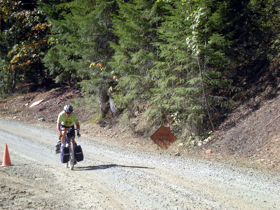
I Should have listened to my mother. If I had, though, I wouldn't have been dragging a fully loaded trailer over 18% ascents through thick gravel, descending corduroy roads trailer bouncing behind through geologic time, or changing my soaking clothes in a filthy men's room in Beatty, Nevada while I shivered and the urinals overflowed."Don't talk to bad men." I should have listened. Doug tells me I must unveil the tale one day at a time so I'll begin with the cast of characters today. Look for more pictures and adventures to come.

Cast of Characters
Death Valley 016
Doug

Doug seems like a pretty sane guy. He likes to take it slow down hill--sees no point in risking injury. I like that. Still he does have that questionable tendency to just take off on a trip which got me into that Weiser River trip last fall. When his mind is set, he's gone. Several times he'd finished dinner and just left. He'd get up some mornings before dawn and just go for long walks in the moonlight.
Suspicious behavior for sure. And then there's the story of Doug's Waitress. I'll save that for later. For now, I should note, I should have recognized the bad man in Doug much earlier.

Death Valley 005
Scott and Jen at Rhyolite
Scott is Doug's friend and former boss from work. They've had 14 years to develop their bizarre relationship. Scott has joined us for rides a couple of times being laid back, never pushing the pace. Who knew he liked to hurt himself? He's run ultra marathons and while they might be in his past, his fundamental masochism showed up on this trip. His dérailleur became fouled so that he couldn't use the smallest front chain ring--granny. He made the toughest climb up Towne Pass in his middle chain ring. In camp he decided to fix the problem which he did revealing that he not only had carried two large cameras and a lot of water but also a well-stocked set of bike tools meant for the bench. Scott pulled two links from his chain earning him a front granny but losing the two largest gears in back. So did he use that granny gear to climb from Stove Pipe Wells to Beatty on the last day? "No. Where's the fun in that?" He might just as well have said, "Hurt me again."

Jen is Scott's fiance. She and Scott are both trained Adventure Cycling leaders. She also helped organize the Idaho Bicycle Ride last year. She has, however, never pulled a trailer before. She probably outweighed her bike and loaded trailer, but not by much. Doug claims he heard her complain a time or two on the big pushes and in the cold, but I never did. And she took more than her fair share of pulls. If she's marrying Scott, she's likely a very dangerous woman.


Death Valley 030
Steve on his Gunner
Steve quit his job to ride across America a couple of seasons ago. What else do I need to say to show you how dangerous he is? Well, maybe that his training plan for this ride was a century ridden after having recovered from breaking the L1 and L2 vertebrae. He figures the best way to get back into cycling shape is to do his first ever fully-loaded mountain bike tour. He even bought new front rack and panniers for this trip. Definitely not safe and sound of body and mind.

Death Valley 059
That's me, the novice tourist on the right (Scott on the left)
Corrie has studiously avoided buying any bike that could reasonably be used on a tour. Some how I fell into this bad company. I don't like to drive farther than than the distance I'm going to bike, so what was I doing 900 miles from home with a freshly purchased Burley Nomad hitched to my mountain bike? Critical mass. With McCracken and Goodenough lobbying for tours and actually doing them and my having no good excuses, I gave in to their blandishments.
I should have listened to my mother.

 Travel to Death Valley Begins:

"Shorts weather," I reported stepping from Scott's Telstar circa 1989 RV onto the pavement in Beatty, Nevada on the 16th of February, 2008. It hadn't been shorts weather yet. In fact we were all prepared for cold. Scott inherited the RV from his mother and, while he had made sure it ran, he hadn't figured out the heating. By the time we picked up Steve in Payette, it was getting cold inside. Those banks of snow we could see along the road fromNew Meadows hadn't helped.  Maybe the drafty windows had something to do with it too. "It's too cold to sleep," Steve said sitting the table in the RV. Doug stretched out on the floor with a pillow just for the occasion and his eyes closed. The RV had a bed but with two BOBs and a Burley trailer, there wouldn't be much human use of that bunk. On the way back, Doug made sure to correct that error.
Death Valley 002
The RV's bed covered in panniers and trailers
Four bikes loaded Doug's hitch on the back, so Steve's Gunner got ride inside, its rear wheel trying to hide in the bathroom, the front protruding into the passenger space."I'm surprised the sleeping bags haven't come out yet," Steve quipped. "Too much work to get to them", I thought, nodding off in my seat.

We started in Lewiston about 2, picked up Steve at the National Guard Armory in Payettte about 7:30 and still had four more hours before stopping for the night in Winnemucca. Scott and Doug took turns driving. Several deer crossing in the dark gave us a thrill and Scott reported some coyote. Four hours and chill to the bone, we pulled into the Motel 6 and Scott switched on the fan. Wonderful. At least there would be a promise of heat for the morning.
Promise was all it was, however. If you weren't driving or riding shotgun, that leaky window sucked all the heat out of the RV. We were treated to bright sunshine and snow capped peaks. Sagebrush dominated the landscape.  Doug promised us a forest but all we saw were scattered junipers and even sadder Joshua trees.
Death Valley 007
A healthy example of a Joshua tree
 
The roadside snow receded as we lost elevation but when we stopped for gas--this RV doesn't pass a gas station (undependable gas gauge)--chill winds and icy footing greeted us.
100 miles from Beatty found all the snow gone leaving mere desolation. The wind was fierce and I began to have second thoughts. "What have I gotten myself into?" Did I just say that out loud?  So now I'm officially chief whiner for the trip. That's okay--the shoe fits. Doug's a little bummed. He thought whining was his job and now with Jen having joined TRC he's no longer the youngest member. "I'm nobody," he complained. Well, maybe he's still chief whiner. In any case we make Doug a TRC board member back in Clarkston at the business meeting. You're somebody, Doug. Just who, we are not sure, though.

So light winds and temps in the high 70s took us by surprise in Beatty. After 15 or so hours of driving, we were anxious to ride out the six or so miles to Rhyolite--a ghost town which once had 10,000 citizens in 1908.

Rhyolite
Skeptical about putting on short sleeves and shorts after having been so cold for so long, we nevertheless suited up and headed out. We couldn't check in yet anyway despite its being nearly three and check in time being 2. Add that to Doug's Waitress story for later.
Rhyolite is not in the park proper and appears to be on private property. Don't picture an old west town. The remains are brick and stone--a school, two banks, and a train station fully restored for a Hollywood movie. A house made of glass bottles embedded in stucco and a mercantile nestled together at the other end of town. Chain link fence marred thet depot and glass house for picture taking but we tried anyway.

Death Valley 009
Glass House with Scott photographing it


Glass house and Scott
Death Valley 004
Train Depot
No chain link fence obscured the impromptu objet d'art we found nearby. An arrangement of statues mimicking the Last Supper. The figures were only empty robes in stark white plaster.Also a giant lego woman knelt in prayer and another ghostly robe held a bicycle--spooky for cyclists heading toward Death Valley.


But most popular was the ceramic couch with toys and pots embedded. We had to have a picture.
Steve reclines
The five of us hitch up our trailers and panniers (Steve, you know who you are) and head into Death Valley. We know we'll hit gravel on Titus Canyon road. But we didn't know how much or how steep. It will be mine and Jen's first experience pulling a trailer. We won't be cold again until the last day leaving the valley. And Scott's discovered the window's open, not leaky. It's all good or seems so . . .


What goes up, must come down. Death Valley Days 2 and 3.

It was Doug’s fault really. At 3500 feet (he’ll tell you 3700), he said, “I could turn around right now and go back to Stove Pipe Wells and sit by the pool and drink a beer.”We started day three at sea level in Stove Pipe Wells planning to ride 30 miles over a 5,000 foot pass to Panamint Springs. The climbing began right out of camp. We had climbed to 5,000 feet twice on day two riding from Beatty at 3200 feet through Titus Canyon over gravel roads and then descending to 0 feet at Stove Pipe Wells. The road was crushed rock, lots of thick sand and ran one way only into Death Valley. The climbing started gently enough at 3 and 4 per cent. Jen pulled at 6-7 mph—slightly faster than I would have liked. Finding the line was tough. Most of the road was too rocky or too soft. The left side seemed best and since there would be no on-coming traffic, we took it.
Death Valley 017
Steve and Scott on the road to Titus Canyon

The park bound traffic, however, was fierce. The most cars the ranger had ever seen. They seemed to come in caravans of five or six: Pickups, small SUVs and many rental jeeps.
But the canyon was supposed to be spectacular. It had better be. Traffic forced you off your bike just when you least could afford to lose momentum. Deep, soft, shifting granular sand mired you wheels and add drag to the trailers.

Jen in particular struggled more. Her cross bike’s narrow tires gave her little purchase and her one wheel Bob trailer seemed to always lean against her direction. Scott also pulled a Bob. Neither had any suspension. Though Scott at least had a hardtail. The jarring would only become worse on the downside. My two wheel Burley Nomad seemed to stabilize me in the sand especially on the downhill. But more stable means it can carry more and as a novice I was over packed—not like Scott with useful tools and lots of water. I had plenty of time to think about what I could have left behind as I pushed through sand and gravel up those 18% grades at 1.6 mph.

Steve, on the other hand, has never pulled a trailer. Front and back panniers and rack for our accomplished road tourist. Though he is out of shape owing to an enforced period off the bike ‘cause he broke his butt, his training plan (riding a century) seemed to work on those two 18% pushes in soft gravel. When the rest of us dismounted and struggled up the grade, Steve stayed in his saddle. . It was his grinning face we saw as we reached the top of each ascent. “It’s the panniers,” he lamely offered as an excuse.“We’re not buying it,” Doug asserted and that was the last we worried about Steve’s being behind.

Death Valley 022
Scott, Jen, and Steve at the top of Red Rock Pass

Red Rock Pass, the first of the two ascents leading into Titus Canyon, is scattered in red dust. No trees or plants grow here. We’d soon learn not to expect plants anywhere. This is a barren,hard scrabble land which has only ever attracted minors and gold seekers and a few foolish cyclists. Now we would get to head down. We worried about braking power and the stability of the trailers. I had never done a descent with a trailer but we saw relatively little of the softest most treacherous sand we had seen on the ascent. In addition the lack of rain meant no washboardy ruts cutting across the road and leaving huge rocks partly exposed capable of snagging a trailer wheel. I actually had little trouble going down. Steve was impressed. Of course, now he thinks I can go ride more nasty trails.
On the second ascent Steve again performed the miracle of the mount while I struggled just to keep moving. Doug was closest behind Steve and came walking back down to help. I was just beginning to wish I had brought a gun, when Doug pushed my bike a few yards for me. I shewed him off to help Jen but she had already off-loaded most of her gear to Scott’s bike. I’d later fix Scott for exposing my weakness, by beating 
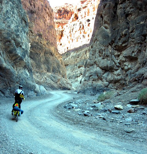
him into camp. But for the moment, thanks for the push, Doug. Once we made the second descent, Doug’s choice of routes was suddenly redeemed by geology. Wide canyon walls swept by some ancient sea had carved through limestone and granite until it opened a chasm to the valley floor.

Death Valley 034
Steve explores a cavern
Each bend saw a new striation of water-worked stone looming high in arched splendor—granite, square blocks, limestone caverns. Strong afternoon sunlight chiaroscuroed the canyon walls with deep shadows and shining stone.

Death Valley 033

“Great choice of route,” Steve complemented Doug. “I forgive you the 18% on the other side,” I added. But now it was 3:30 and Stove Pipe Wells was 20 miles away. Motorists had been telling us all day that the camp ground was full on this three day weekend. Would we find a camp spot or go mendicant in the desert?


Only three miles separated us from smooth pavment. We though we could make it, but we hadn’t counted on a sea of lose gravel for those 3 miles. Doug and I put one foot down and scooted through the sand.  Doug hurried off, perhaps, in an attempt to take responsibility for finding us a camp spot or perhaps because that is what Doug does. I rode a bit with Steve while Jen and Scott brought up the rear. I hadn’t planned trying to catch Doug but when I pulled away from Steve and finally spotted Doug's sturdy form pulling a yellow Extra Wheel, I couldn’t resist giving chase. I figured we’d trade pulls into camp and secure a spot together. But when I caught him, he seemed to lose heart. I sped on to camp arriving in Stove Pipe Wells right at 5:30. It would be dark by 6:00. It took some time for me to figure out the camp situation and both Doug and Jen had arrived as we learned we’d have to camp in an RV lot. It didn’t really matter since it was all the same rock. We lacked only a table.

our campsite for days 3 and 4
Scott had different priorities. When he rolled in, he wasn’t in a hurry to pitch tent. Instead he handed out cold beer. He’d stopped at the General Store—good man.

Stove Pipe Wells Village.  That's a pool of mineral water on the left.  Water was discovered here and marked with a length of Stove Pipe

Day 3
So it really was Doug’s fault that we turned back on day three. The plan had been to ride over 5,000 ft Towne Pass to Panamint Springs, spend the night and then return via Emigrant pass the next day. But Towne Pass was a different animal. At the bottom a sign warned us to avoid overheating by turning off our AC. The sign reported we had 20 miles of climbing. This was supposed to be an easy 30 mile day. Towne Pass doesn’t switch back giving you relief. Instead it climbs relentlessly at a steady 6 to 9 percent with some 10 percents sneaking in there. We were fully loaded.
Death Valley 039
Rest stop at intersection with Emigrant Pass
At 3500 feet we began to see the world more clearly. We weren’t sure we could do that much climbing day after day and still be able to climb over Daylight pass to Beatty on Wednesday. When we gave up the idea of riding back on Emigrant Pass, riding to Panamint Springs didn’t make sense. Maybe the beer by the pool, was too attractive. Scott, lover of suffering, and Jen chose to continue to the 4000 ft marker before turning back. Doug and I left immediately. Steve followed soon. Actually this turned out to be the best decision we could have made. On the next day, we’d ride the relatively flat 25 miles to Furnace Creek for lunch and then back. Along the way desert primroses were said to have made the desert bloom yellow and we’d also have a chance to explore Salt Creek for the elusive pup fish.  But the climb to Beatty looms in the back of our minds. Pavement or no, if it hits 18% again, I’m pushing.

 2/19/08 Tuesday day 4. Stove Pipe Wells to Furnace Creek and back 52 miles

Mountains abound
Death Valley lies open before me as I descend from Towne Pass. Distances are deceiving. Everything seems closer than it is. The rim of mountains around the valley seem easily reachable. They are not. I'm doing 37 mph, my nomad trails smoothly unnoticed behind me. I brake only to avoid RVs whose own brakes stink. The grade is 9% and probably more.
The narrative of our Death Valley Days has taken a darker turn. We had planned to ride over Towne Pass and return the next day. Instead good sense prevailed and we turned back.
We consoled ourselves that this was not a defeat. We planned a better ride to Furnace Creek which promised flowers, flowing water, and perhaps the pup fish. But the truth of the matter was that we had been turned back from one pass and had no alternative but to ride another just to get back to Beatty and our RV. This was beginning to sound like one of those disaster stories about pioneers who stumbled into Death Valley. Those tales never seem to end well.
Our road tourist, Steve, says he now understands the scariest sign a cyclist might see is that "Avoid Overheating; turn off your AC" we had spotted at the bottom of Towne Pass.

Conversation always seemed to turn to that final climb up Daylight Pass to Beatty. We wouldn't take our trailers to Furnace Creek and the route to Beatty was reputedly easier there. We could let Scott return to Beatty to retrieve the RV and rescue us. We are a sturdy lot. Steve likes the challenge of a hill and promises us that he will be able to get over Daylight Pass. I'm not so sure about myself but none of us want to be rescued yet. We might unhitch the trailers, cache them, and ride on to Beatty without their weight coming back in the RV. Some version of that scenario allowed us to rest and enjoy the day ride without trailers to Furnace Creek.

We set out for Furnace Creek light-heartedly. This would be 50 miles round trip with no major climbs though we'd see sea level from both sides descending as much as 242 feet below it.
Death Valley 053
Jen and Steve pose at the below sea level sign
We stopped at Salt Creek and hiked the board walk 8k along a flowing stream of surface water in the desert.
Death Valley 051
Salt Creek
All this had once been a fresh water lake but salination increased as it dried. Few creatures could make the relatively sudden transition from lake to desert. Only the pup fish evolved and survived in this one strange phenomenon of a flowing stream of salt water starting nowhere and ending there as well. Sadly, the pup fish is subject to predation by the Blue Heron and has learned discretion. We couldn't find even one.
Jen, Steve, and Corrie walking the board walk
Furnace Creek is the largest development in Death Valley. It loses something by gaining manicured date trees and palms and a golf course. We sat at a park bench and ate dates from Death Valley date trees which Doug plundered and taught us the eating of. They are much smaller than dates you'd buy but just as sweet. Lunch was good and uncharacteristically so was the service. Doug's Waitress--wait for it. 

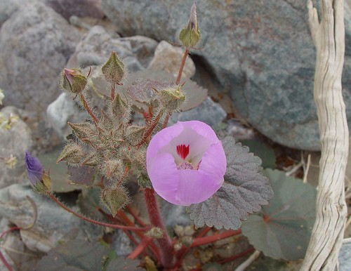
Along the route yellow desert primroses scattered thinly along the roadside and rocky slopes and occasionally mounted a satisfactory display. Scott poetically called them a river of yellow at the club business meeting. I think he exercised some poetic license there.
Death Valley 054
more a puddle than a river
But any show at all of life was welcome and astonishing in this rocky barren. Rainfall is spotty and so too are the yellow blooms. Apparently Stove Pipe Wells had not received enough rainfall to stimulate the desert bloom.

Scott, the flower dude
We enjoyed stopping to take pictures, not pulling trailers, and occasionally giving one another chase. But always there remained the question of Daylight Pass and the road out. It's not an adventure if you know you can do it. It turned out to be both better and far worse than we had imagined.


Day 5 "I should have listened to my mother"

It's a quarter past 1 and I'm hitting 25 downhill into Beatty. My acceleration only makes the driving rain pelt me harder. My gloves, long since soaked through, profid no warmth. My shoes are full of water despite my having put plastic bags over my socks."We are looking at it with Northwest eyes," I told Scott Wednesday morning in camp. I had gotten up at three to the usual strong moonlight in a clear sky, but by 5:30 I began to feel chill in my tent and the sky had clouded up. A wall of grey covered the northern end of the valley and another seemed to close in from the southwest."it's just desert fog," I fabricated. Staying in bed wasn't an option, though. Today we would make the climb over Daylight pass back to Beatty and, we hoped, make at least part of the drive home.

sunrise on the last morning
We had agreed to go to breakfast before breaking camp, but we had all lied. We got up earlier than usual and made whatever progress toward breaking camp we could. I think we were all anxious about the climb and anxious to get started. Back from breakfast we hurriedly broke camp. The weather wasn't improving. We managed to head toward the pass about 8:30 trailers and panniers doing nicely thank you until we hit the bottom of Mud Canyon.

making the turn to Daylight Pass
We took a break and I removed jacket and leg warmers. Was that a drop of rain?

Corrie readying for the climb
A car pulled up, driver grinning. "Anything you want me to haul to the top for you?"
"You can just put me on top, there," I said. But Scott chimed in that this is "all part of the experience." What a guy, that Scott.  A total of 30 to 35 to reach Beatty. We had already covered 8 or 9. We figured we'd have thirteen miles of climbing. We feared the grade after Towne Pass though we knew this one only climbed to 4300 feet. Doug scooted off ahead as usual. I was next with Scott and Jen riding together and Steve taking up the rear. We expected him to come by us before the top.

The grade was mild if you think 5 to 6 percent pulling a trailer is mild for much of the way. The light rain actually felt good on my skin. I felt strong and quickly found a rhythm of spinning that I'd alternate with a bit more pushing that kept my pace at 6 mph. Just as I thought I was going to catch Doug, though, I had to stop. Light rain had become the real thing. If I didn't switch to rain gear soon, I'd be soaked. By the time I had the rain jacket on and plastic bags in my shoes, Scott and Jen had caught me. We had done about 5 miles and now it wasn't the grade we worried about so much as being wet and cold.

Doug stopped at the rest stop at the intersection with the road to Furnace Creek. I pulled in too and put on my leg warmers. I was warm enough moving though I had had to drop to 3 and 4 mph by now. Scott and Jen showed up. Both were cold. We waited for Steve, but by the time he got there I was beginning to shiver. I told him I had to go to stay warm. He understood.
Doug and I took off more or less together the rest of the way. No AC warning on this slope gave me hope that it wouldn't get much worse. Nor were there any cheery little signs reporting the elevation. No mind. I had my GPS. I stopped looking at miles, grade, or average pace. Who cared? What I wanted to know was how many more feet of elevation must I gain to the top? And it worked. Every few strokes I'd be rewarded by a 1 or 2 foot jump in the elevation. 900 feet, 800 ft I told myself. When I stopped to wipe the rain and sweat from my eyes, Doug told me it was 4300 feet not 4200 as I had been expecting. Okay, 600 ft, left not 500.
Daylight pass has more turns than Towne. You could make a goal of each turn, each horizon. It helped.

That's 4300 feet on the signe in back of me.  Do I look wet?
. I planned to put on warmer, drier gloves at the top but had trouble finding them and when Doug said he wasn't stopping, I mounted up and headed down. Fortunately the steepest section was pretty short and I didn't suffer much from the cold. I had a couple of landmarks to look for on the way back to Beatty. One was the Titus Canyon cut off and the other was Rhyolite. They'd seemed fairly far from Beatty, but now I rode endlessly before finally passing them. Ahead of me in the drizzle the road way was a shiny ribbon and it looked to be climbing high and to the left. I don't remember that, I thought. But an oncoming car demonstrated that, yes, I'd have to climb again. It hadn't seemed like much on Saturday but soaking wet pulling a trailer changes how you see the world. That hill was just a false top too. Leveling out a bit, it climbed again before finally dipping down into Beatty.

Cold and wet and anxious to get back to The Nut and Candy Shop where I knew there'd be a bathroom in which to change, I nevertheless had to come to a full stop at Beatty's only stoplight. Doug was only minutes behind me and he had a key to the RV. "Watch the bikes," he
said rushing off to the RV.

Steve had made it to that last hill that had hurt me so much before Doug picked him up. Scott and Jen were still on the Beatty side of Daylight pass. Walking. Cold, tired, shaky, Jen didn't trust her bike and dismounted to walk. Scott found his rear brakes wouldn't stop him.
Doug performed his rescue while I peeled off wet layers in a filthy men's room. The unfamiliar rains had caused a urinal overflow. Black bags covered the three stations and the floor, though dry, looked stained. I did my best not to put anything down directly on the floor. Now where's that pair of underwear? NO, it's in the trailer and I'm naked. So the jeans came on anyway. But by the time I found the underwear and stuffed them in my pants, maintenance had arrived and closed the men's room. Damn.

I wanted to sit by the glass doors and watch the bikes, but I couldn't. Maintenance had a hose running in and kept the door wide open. Dry clothes or not, I wasn't warm. I don't usually drink coffee but I needed the warmth. I had two cups.

No bikes! Had maintenance moved them? Why? I confess to a moment of fear before I realized Doug was back with the RV. Oh, and I corrected the underwear problem in the RV before we left.  Alive, mostly dry and well, you'd think the adventure was over but no. It became apparent that we were driving through. Scott took a nap on the bed while Doug continued driving. The heat was working when we left Steve off in Payette, but it soon ceased. I grabbed my sleeping bag and crawled in.

My Gps shows 177 miles, 17 hours and 21 minutes riding time, and 14,000 feet of climbing (Probably more 'cause mine shut off for the top half of Daylight). My average heart rate was 136 but I saw 178, the highest I've ever seen.
I shoulda listened to my mother.

Doug's Waitress an epilogue
 Doug doesn't wear a watch. He'd been known to get up and walk in the moonlight taking desert sunrise photos.

Doug's Sunrise Shot
He often didn't join us at the Tollbooth Restaurant for breakfast either despite having claimed that at home he must have breakfast upon rising. This morning he had decided to join us with the caveat, "If she's there, I'm not staying." "She" meant Doug's waitress, a dishwater blonde, who as Doug knew was always there.To tell the truth, since leaving Idaho, clerks and service staff had looked askance at us. It became difficult to get anything more than a yes or no.

An inquiry at one convenience store about a building on the hill got no response. In Beatty I ordered whole wheat toast which other than in thickness resembled the sour dough Scott had ordered. The blonde middle aged waitress had trouble telling one from the other. When I asked about a grocery store at a Food Mart in Beatty, the first clerk said "No" and kept bagging. The second did stop me to give directions to two places where I might find some groceries.The desk clerk at the Motel 6 seemed a bit haggard when we arrived at 2:30. We thought we'd check in and then go for a ride. But when we asked if we could check in she said, "No, check in is at 2 . . er, 3." That was okay buy us since we wanted to go for a ride. We changed in the RV and wrote off oddness. In Stove Pipe Wells where we'd arrived at dusk after 7 hours on the road, tired, hungry and thirsty, the Tollbooth restaurant didn't seem anxious for our business. Seating by invitation only is one thing but they took one look at us, granted we hadn't showered yet, held a tete-a-tete and told us we'd have to wait in the lounge--about 30 minutes. We could see many empty tables.

The lounge was pleasant enough but had no waitress. One had to belly up to the bar which Scott promptly did. Sometime later I joined him. He's far more patient than I and took it all good naturedly. I'm sure another fellow came engaged teh bar keep in conversation, order a drink and got it. But I can't prove.

We finally did get our drinks (Save Steve who wanted only water but hadn't bellied up to the bar). Another group were playing pool when their reservation was called. Scott happily volunteered that we were ready and would go to dinner, but the pool players were encouraged to finish their game.

Waiters and waitresses alike seemed unable to distinguish one of us from another often miss-delivering orders wildly with no seeming clue to what went where. We didn't really mind that but it did begin to seem that all cyclists looked the same.

Scott and Jen said they were on one check. The rest of us--three men--assumed we'd get separate checks. I don't think we made that clear enough. We got one check. I was tired and didn't want to fool with the math. I took the check and asked for separate checks. "You'll have to deal with your waitress," the manager told me.

They didn't like it and the manager told Scott on the way out that we'd have to ask for separate checks in the future which we were always certain to do. It probably didn't help that Doug and I had split a piece of key lime pie. We told the blonde to put it on my check. She didn't. Instead she brought me Doug's Check. We just paid it. We had clearly over-taxed her skills.

Tollbooth is the only game in town unless you are satisfied with a muffin and juice at the General Store which is what Doug did the next morning. But at dinner we were told "Your waitress will be right with you, or, your waiter." The tall slender man got clear instructions about the checks but had as much trouble telling us apart as the blonde. At the third dinner, however, the place was busy and the manager seated us in the blonde's area. She asked us if we were the cyclists who had sat up front. We said we were. She immediately left us to consult with the manager. No, go, honey. That's your table. Sullen service with your coffee, anyone?
The manager always met us with a cheery greeting and convivial bonhomme that I don't like. "How are you kids?" he'd ask. But we never had to wait again and the checks were always right. Because we had skipped Panamint Springs, we took about six meals at the Tollbooth.
To be fair, it must be difficult to get good help in the middle of the desert. We were at breakfast at 7 each morning and at dinner until 8. The same three people were on duty every time we were there. Long hours. Short staff. No wonder we had to wait on Sunday during there busiest weekend. Wonder what the pay's like? Apparently tips might be tough to come by if you ask Doug.

Oh, yeah, and there was the matter of Doug's bike shorts that first evening. We had finished dinner and were waiting for the check when Doug grabbed a fork, pushed back from the table, looked both ways, and promptly used a tine to release the knot in the string. "Ah," he sighed. "That's been bugging me all day."  Cyclists got no couth.

Doug's Pics on Flik
r If he puts up more shots, you'll have to page through to find them but on 2/25/08 they are first in the list.

Corrie's pics on Flikr These point to a folder and should always stay available.